Aboriginal Launceston
Envisaging Landscape
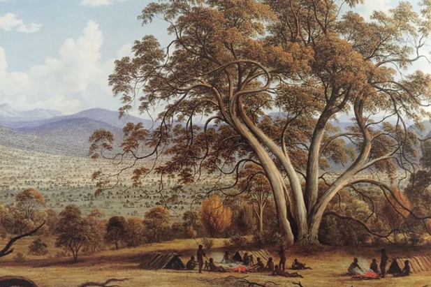
John Glover “Mills Plains”. TMAG Hobart
This was painted in the 1830s after actual occupation of the area by Tasmanian First Peoples – they were ‘painted’ into the landscape. But note the extraordinary regrowth of invasive wattle [acacia melanoxion] – and remarked on by Glover – in the background indicating cessation of firing of the landscape. The big gums were preserved by “cool” firing which suppressed regrowth seedlings.

A Vast Estate Managed with Purpose
A Vast Estate Managed with PurposeIn 2011 Bill Gammage published his controversial, The Biggest Estate of Earth: How the Aborigines made Australia. He refuted the idea of Aborigines as nomadic wanderers idling across the landscape. Instead, he saw the Aborigines as...
Is there evidence today of the landscape of the First People?
Is there evidence today of the landscape of the First People?Actually, there is a lot of evidence if we know how to “read” landscape though intense modification of the Launceston basin makes that more difficult at that location. This scene from the northeast seems...
What does past practice mean in the present?
What does past practice mean in the present?The substantial alteration to the landscape by First Peoples does not give permission for us to treat the present landscape as a blank slate to be scribbled on. White intrusion interrupted Indigenous landscape maintenance by...
What would the place have looked like without those First People gathered on the shore?
What would the place have looked like without those First People gathered on the shore?If you had sailed up the Kunermulukerker, the Tamar, in the wake of the first British interlopers what would the landscape have looked like WITHOUT First People presence and...
Why multiple names for the river?
Why multiple names for the river?Many languages use generic names with adjectival qualifiers e.g “Grey Kangaroo” where “Kangaroo” is the basic word for the animal and “grey” is an adjectival qualifier that broadens our understanding of the basic generic word....
The Launceston Basin

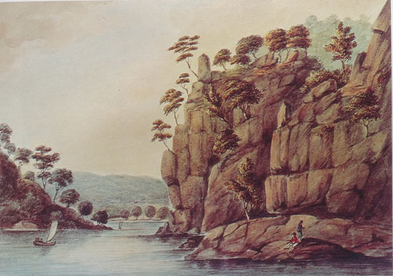
The Gorge 1808: Still a recognisable Aboriginal Landscape. George Prideaux Harris, ‘Near Launceston, Port Dalrymple, Van Diemen’s Land 1808’ [Mitchell Library, State Library of NSW]

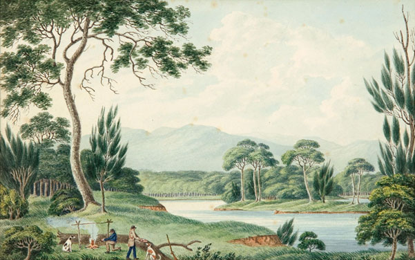
Joseph Lycettt (1774-1828) View Upon the South Esk River. Art Gallery of South Australia. Ref Link
So why land on Launceston?
What made the Launceston Basin so special?
Launceston is a rich borderland, a place where boundaries meet – where saltwater and freshwater meet, where the First People of the Northern Midlands interface with the riverine people of the Tamar, where the wetlands border the game plains. Because of the interface of saltwater and freshwater this means that landscape abundance is amplified by the diverse ecology.
This, along with the intense landscape modification means the Launceston basin – where the Esk rivers and the Tamar meet – was a densely populated place of First Peoples seasonal habitation.
This was a vast wetland rich in waterfowl and swans, eggs, mussels and oysters, and a variety of edible plants, as well as plentiful grass and game in the grassland of the adjacent hinterland which means in the spring and early summer it was a magnet to the First People.
And by the way, it is one of the reasons white occupation centred here as well. The British, learned from the Dutch, the value of the nutrient rich alluvial wetland soils. When drained these soils were highly productive.
First People engagement with the landscape encouraged the dominance of certain species. Intense human landscape interaction has been shown historically to alter the balance and dominance of selected species. Plants follow in the paths of favoured human selection.
But far from the present tendency to over exploit, those plants and animal species that were favoured foods were nurtured and encouraged to become dominant – plants follow human need and respond to it.
This is not so much ‘sustainability’, as methodical, conscious decisions to factor in future resource needs.
The Geomorphology of the kalamaluka-Tamar Valley
The Geomorphology of the kalamaluka-Tamar Valley Tom Dunning Formation of the Tamar Graben The kalamaluka-Tamar Valley is the product of 200 million years of geological evolution. The story begins at a time when the old super-continent of Gondwanaland began splitting...
Sutton and Dark Emu – Does this amount to ‘farming’ or ‘agriculture’?
Does this amount to ‘farming’ or ‘agriculture’?Bruce Pascoe’s Dark Emu has stirred considerable controversy and recent work by Peter Sutton & Keryn Walshe has subject it to critical academic analysis. Not only questioning some of his evidence, they believe Pascoe...
Tamar Valley Geology and British Settlement
Tamar Valley Geology and British Settlement Addendum: to Tamar Valley Geology Determining the First Peoples Occupation of Northern Van Diemen’s LandAddendum: to Tamar Valley Geology Determining the First Peoples Occupation of Northern Van Diemen’s Land Abstract The...
The Garden that became Launceston
The Garden that became Launceston Jamie KirkpatrickSchool of Geography, Planning and Spatial Sciences, University of TasmaniaRivers wear away the ancient Tasmanian mountains, depositing their mineral wealth in flood plains and estuaries. This depositional richness is...
Does this amount to ‘farming’ or ‘agriculture’?
Does this amount to ‘farming’ or ‘agriculture’?The work of Bruce Pascoe’s Dark Emu argues for a substantial shift in language from ‘hunter-gatherer’ to terms like ‘farming’ and ‘agriculture’. Certainly, Indigenous land use has suffered the suggestion of ‘savage’ and...
Understanding How First People’s Viewed Their World
An Encyclopedia of Tasmanian Aboriginal Anthropology
An Encyclopedia of Tasmanian Aboriginal Anthropology BARRY H. BRIMFIELD 2020 CEARCHAEOLOGY – ITS HISTORY On the 18th February 1802 the Botanist, Leschenault, of the French exploration expedition led by Nicholas Baudin while at Maria Island, came across a small mound...
An Encounter with the First People of Northern Van Diemen’s Land
An Encounter with the First People of Northern Van Diemen’s Land 1642 – 1812, Tasman to the end of the First Epoch Ian Pattie, July 2021Abstract Dutch, French, and British explorers set foot in Van Diemen’s Land from 1642 bringing with them a range of preconceptions...
FOOD FORAGING (PART 2 “FORAGING & FOOD PREPARATION”)
FOOD FORAGING (PART 2 “FORAGING & FOOD PREPARATION”)Part 1 “Food Resources” summarised the available fauna and flora, this final section briefly explains the techniques used to obtain the protein and carbohydrates contained within them by hunting, gathering and...
FOOD FORAGING (PART 1 FOOD RESOURCES 2,000 > BP)
FOOD FORAGING (PART 1 FOOD RESOURCES 2,000 > BP)The Tasmanian Aborigines occupied their island home for at least 40,000 years but it is only the last 2,000 years that is considered here and only mainland Tasmania and offshore islands. A relatively rich area of...
An Encounter with the First People of Northern Van Diemen’s Land A Particularistic Mindset
An Encounter with the First People of Northern Van Diemen’s Land A Particularistic Mindset Ian Pattie, July 2021When Lieutenant-Colonel William Paterson brought a group of white settlers – soldiers, convicts, and farmers – to Port Dalrymple, Van Diemen’s Land, the...
Tamar Valley Geology Determining the First Peoples Occupation of Northern Van Diemen’s Land
Tamar Valley Geology Determining the First Peoples Occupation of Northern Van Diemen’s Land Ian Pattie, November 2020Abstract The forces of nature – volcanic, glacial, fault and the like – lay down a rough-hewn sculpture upon which other weathering forces produce a...
An Encounter with the First People of Northern Van Diemen’s Land
An Encounter with the First People of Northern Van Diemen’s LandPart 1: Tamar Valley Geology determining occupation When William Collins sailed down the waterway now known as the Tamar, in January 1804, he eventually reached and entered a river to the East, the North...
Adequacy
AdequacyIt is tempting to apply modern terms like ‘sustainability’ to Indigenous practice however the key to understanding First People’s attachment to country is adequacy. First Peoples did not expend energy on wasted accumulation but on a vast Estate that provided...
A “grounded” rather than “portable” faith – A Psychic Invasion.
A “grounded” rather than “portable” faith – A Psychic Invasion.Europeans have always had difficulty in grasping a concept of religion in Indigenous practice and even denied until the mid 20th century that you could apply the term ‘religion’ to Aboriginal practice –...
Tamar Valley Geology determining occupation
Tamar Valley Geology - Tamar Valley Geology determining occupation. Ian Pattie. When William Collins sailed down the waterway now known as the Tamar, in January 1804, he eventually reached and entered a river to the East, the North Esk, and wrote in his logbook: There...
Holocene Tasmania
Four hundred metres long and a metre high: What were these middens?
Four hundred metres long and a metre high: What were these middens? By Michael Powell.The considerable size of some Aboriginal middens raises questions. These are constructed consciously and deliberately – they are not the result of people idly tossing discarded...
PALAEO ARCHAEOLOGY OF THE TAMAR VALLEY
PALAEO ARCHAEOLOGY OF THE TAMAR VALLEY December 2020Human history in the Tamar Valley could extend back some 40,000 years considering that at least one site in the upper Forth River 200km west has such a basal date, but the Tamar lacks sites, caves, that could confirm...
Ochre
"Ochre” Barry H. BrimfieldBecause of respect and to minimise vandalism the exact location of sites is only approximate. What is Ochre? Ochres are earthy, pulverulent (reduced or crumbled to powder or dust) forms of Haematite and Limonite or friable (easily crumbled),...
Tamar Middens
Tamar Middens By Nigel BurchIn early 1801 Philip King, now Governor, decided to establish a government coal mining operation at Newcastle. Although the expedition was nominally under the command of another officer, it included William Paterson, newly appointed as...
Ochre Exploitation Around the Tamar
Ochre Exploitation Around the Tamar By Nigel BurchUntil very recently it was thought that Tulampanga, near Mole Creek, was the only source of high-grade ochre available to Indigenous peoples. Europeans in the 1820s discovered some of the best-quality ochre in...
Tamar Valley’s Palaeo Aboriginal History
Tamar Valley’s Palaeo Aboriginal HistoryThis work, which comprises the three separate study papers, was put together being all connected to the Tamar Valley’s Palaeo-Aboriginal history. As the reader progresses they will see that included are remarks on areas just...
Tasmania’s Aboriginal Palaeo Art
Tasmania's Aboriginal Palaeo ArtBarry H. Brimfield 2013 This work is a collection of papers each pertinent to the art produced over thousands of years by the Palaeo-Tasmanian Aboriginal people. Their art had roots extending back to their original homeland "Africa", to...
Follow us on FaceBook
Problem displaying Facebook posts. Backup cache in use.
Click to show error
